INPUT
→Reconnoitre and control
Set purpose, scale, baseline, stations, signals, anchorage and tide site.
A real Age of Sail career dossier · 34
Hydrographer · Sea Surveyor · Marine Surveyor
The specialist who gave every depth a position, time and evidential chain amid wind, tide and a moving boat.
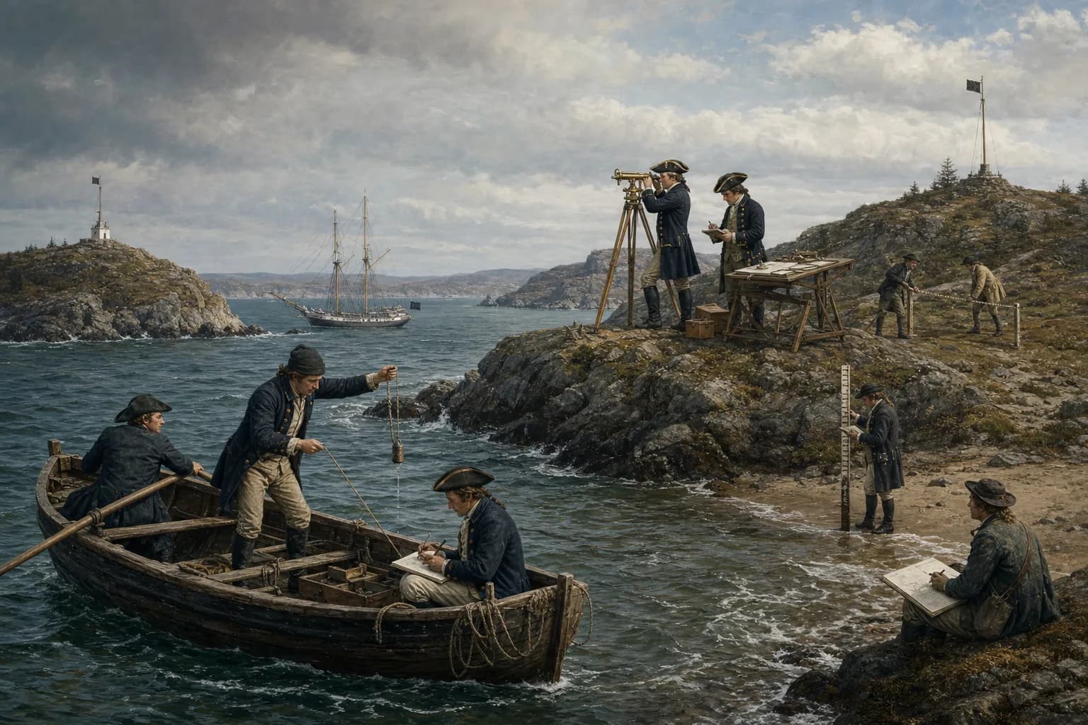
An Age of Sail hydrographer or sea surveyor obtained positioned evidence of coast and depth in the field. A systematic eighteenth-century party first reconnoitred a bay, measured a shore baseline and used a theodolite or other angle instrument to extend triangulation to headlands, islands and temporary signals. It then surveyed shoreline, landmarks and coastal profiles while shallow-draught rowed boats repeatedly cast a sounding lead along planned lines. Every depth required a position and time. Tallow in the lead's base could recover mud, sand or shell, while a tide staff or repeated water-level observations separated changing sea level from the seabed. Angles, soundings, tides, names, sketches and remarks entered field books, boat sheets and an original survey before a chart-room cartographer, engraver and publisher made an issue chart. 'Hydrographer' could also name an official keeper and publisher of survey material, as after the 1795 appointment of the Hydrographer to the Admiralty; the title alone does not prove daily field survey. Cook combined naval command, survey and chartmaking, while Des Barres crossed survey, compilation and publication. Their composite practice should not erase the separate liabilities in a larger system.
Information arrives, judgment forms, and work passes on through a complete watch.
Set purpose, scale, baseline, stations, signals, anchorage and tide site.
Complete triangles, shoreline, landmarks, profiles and astronomical checks.
Run planned lines for positioned depths, bottom, time and water level.
Check closure and gaps, resurvey anomalies, deliver the original survey.
Centered dense depths, shoals, channels, tides, anchorages and shore marks.
Centered long coastal outlines, headland position, profiles and major hazards.
Joined safety to fleet access, fortification, secrecy and territorial claim.
Measure baseline, erect signals, observe angles, calculate triangles and test closure.
Plan lines, boat spacing and density to cover the most dangerous terrain in limited time.
Relate depth to tide and identify mud, sand, shell or hard bottom returned in tallow.
Keep station, time, depth, position, weather and uncertainty accountable.
Institutions, experience, patronage, and opportunity shaped each person’s route.
Begin with logs, boats, signals, chain, lead and field-book discipline.
Own a shore station, a sounding boat or a working sheet.
Design a survey and own control, coverage, tides and original record.
Direct ships, parties, archives, standards, publication priority and state issue.
The field surveyor's primary deliverable was not a handsome published chart but a reviewable body of observations: baseline, shore angles, astronomical position, shoreline detail, individual soundings, bottom character, tides, currents, landmarks and dangers. A cartographer later reconciled the survey and other sources to a projection, scale, symbol system, names and edition; engraver and printer made the plate and impression.
Titles shifted with institutions. An eighteenth-century marine surveyor might also navigate, fair-draw and write sailing directions. The Hydrographer to the Admiralty created in 1795 was primarily head of a collection and publishing operation; Alexander Dalrymple was not perpetually in a sounding boat. Career identification must ask who planned fieldwork, controlled original-survey quality and answered for position and depth.
An Admiralty, company, colonial government, harbour authority or expedition set the requirement: one port, a coast, fleet anchorage or river approach. Purpose governed scale, season, party, boats and sounding density. A reconnaissance sheet might plan a passage but could not take a deep-draught warship through a reefed entrance; a harbour plan demanded more controls, shoreline, depths and tide detail.
On arrival the surveyor questioned pilots, fishers and residents, compared old charts, wreck reports and landfalls, then examined headlands for instruments, level ground for a baseline, anchorage for a mother vessel and a site for a tide staff. Local knowledge directed attention to shoal, current and weather but was recorded separately from repeated observation. Fortified or contested coasts added permission, hostile observation and secrecy.
A systematic survey repeatedly measured a baseline on reasonably level land with chain, rods or other standards, accounting for slope, tension and direction. Its endpoints became known points. A theodolite, circumferentor or period-appropriate angle instrument sighted a third signal and fixed a triangle; successive stations carried the network across bays, headlands and islands. Parks Canada describes Cook's 1763–67 Newfoundland work as the first large scientific hydrographic survey to establish land outlines by precise triangulation.
Signals could be poles, flags, cairns, cloth or temporary platforms visible from several stations. Field books named each angle, station, weather and repeat; poor closure demanded another observation. Des Barres reported extending theodolite bearings from a 350-fathom shore baseline to offshore islands, then giving controlled plots to vessels of different sizes to survey coast, rocks and soundings—a clear land-to-water system.
With control in place, a topographic party used plane table, compass, chain and sketch to fill shoreline, river mouth, islet, fort, settlement, beacon and conspicuous hill. High-water edge, drying mud and low-water rock could not be collapsed into one line. Astronomical latitude or longitude could place the local network more broadly, but instrument, timekeeper, weather and calculation constrained it.
What land looked like from the water also mattered. A draughtsman or officer drew profiles showing how tower, twin peaks, cliff and island overlapped on approach. The Atlantic Neptune's combination of charts and headland views was functional: before precise universal positioning, mariners matched a visible landfall to the recorded profile as part of entering safe water.
A boat ran planned sounding lines. The leadsman cast a marked hand lead ahead so the line approached vertical as the boat came over it, called the fathoms, and the recorder wrote reading, time, line and anomaly. A pole served very shallow water. Mother vessel worked deeper zones and boats entered creek, shoal and surf, yet all measurements remained discrete points; wider line spacing increased the chance of missing an isolated rock.
Shore bearings, boat compass, intersecting angles or later mature three-point fixes placed the observation on a working sheet. Current, wind and boat motion slanted the line; haze hid signals; one copied numeral displaced a danger. NOAA's account captures the limitation: an individual lead-line depth could be accurate while coverage between soundings remained absent. Quality included what was not observed.
A hollow under the sounding lead held tallow that returned mud, sand, gravel, shell or other material. Bottom character helped a mariner recognize position and judge holding ground, reef or channel edge. The Rijksmuseum's lead documents this form of deep-sea hand lead from at least the seventeenth century, grounding bottom sampling firmly in the period.
The same seabed yielded a different water depth with the tide. A party read a staff or fixed mark at intervals and matched each sounding time to water level. Eighteenth-century services did not share today's standard chart datum; weather setup, river flow, short observation and imperfect tide understanding limited reduction. A sound record preserved actual reading, time, station and reference so a later office could reassess it.
An officer-surveyor or master might direct assistants, midshipmen, draughtsman, astronomical observer, carpenters, seamen and local pilots. The mother vessel provided lodging, instruments, repairs, provisions and offshore soundings. Shore parties raised signals; boat crews rowed, steered, cast, called and wrote. A precise angle attached to the wrong station or depths without correct time could invalidate a day.
Hazard concentrated in the small boats: surf, fog, cold, cross-current, hidden rock, capsize and separation. Shore hands met cliff, bog, insect, sickness, supply failure and hostile fire. Fair weather with the wrong tide, or calm water with signals lost in haze, was still unusable. The commander traded coverage against density, season and fatigue every day.
At day's end, angles, baseline notes, astronomical observations, depths, bottoms, tides, weather, names and sketches entered numbered records. A working sheet joined stations, lines and individual depths under common control. The leader checked gaps, suspicious shoals, closure and provenance, then ordered resurvey. An original survey or fair sheet retained field facts and method before chart-room generalization and engraving.
The UK National Archives' ADM 352 preserves original surveys from 1713–1831 alongside coastal artwork and logs, showing that field record and issued chart were separate layers. Cook and Michael Lane's 1775 Newfoundland print carries graduated borders, rhumb lines, depths and seabed notes, but it is already a published object in Thomas Jefferys's system. Collapsing field officer, cartographer, engraver and publisher hides where an error entered.
Early entrants came through navigation, ship's master service, naval office, army engineering or land survey. They needed arithmetic, geometry, astronomy, instrument adjustment, boat handling, drawing and disciplined record, plus the ability to make seamen repeat accurate sounding runs. Cook learned triangulation at Halifax and led the Newfoundland survey; that field success helped open his Pacific commands.
Pay might be naval salary plus special allowance, seasonal commission, company or colonial contract, and sometimes publication or patronage. Des Barres combined military office, survey and engraving or publication. Dalrymple moved from East India Company journals and chart publishing to first Admiralty Hydrographer in 1795. Surveying was beginning to become archive, standard, programme and distribution system, though much Age of Sail work remained local and ad hoc.
career.hydrographer
The field hydrographer established shore control and recorded positioned coast, depth, seabed, tide, landmark and danger observations, delivering a reviewable original survey.
Not necessarily. A field hydrographer gathered primary evidence; a cartographer compiled and drew it. An official Hydrographer might instead manage archive and publication. One person could combine roles.
They used a marked lead line or a pole in shoal water. A leadsman called the depth while a recorder captured position, time, tide and sometimes the seabed sample.
Each depth needed a position. A measured baseline and shore triangles created known control points from which bearings or angles fixed the sounding boat on its working sheet.
Tallow in the hollow base picked up mud, sand, gravel or shell, revealing bottom character for recognition and anchoring.
Not safely without its tide, reference, unit, position method and reduction. Historical services did not all use one modern vertical datum.